Patent application title: Helicopter autopilot
Inventors:
Ron Wayne Hamburg (Sacramento, CA, US)
IPC8 Class: AG05D100FI
USPC Class:
701 11
Class name: Aeronautical vehicle altitude or attitude control or indication auto pilot
Publication date: 2011-01-27
Patent application number: 20110022250
Inventors list |
Agents list |
Assignees list |
List by place |
Classification tree browser |
Top 100 Inventors |
Top 100 Agents |
Top 100 Assignees |
Usenet FAQ Index |
Documents |
Other FAQs |
Patent application title: Helicopter autopilot
Inventors:
Ron Wayne Hamburg
Agents:
RON WAYNE HAMBURG
Assignees:
Origin: SACRAMENTO, CA US
IPC8 Class: AG05D100FI
USPC Class:
Publication date: 01/27/2011
Patent application number: 20110022250
Abstract:
The Helicopter Autopilot operates by recording GPS (Global Positioning
System) and/or accellerometer coordinates on CD-ROM during a programming
flight or maneuver. To autopilot this flight plan, the received GPS
coordinates that show the pilot's real-time position, will be compared
with the programmed GPS coordinates that represent the magnetic course
high-lighted on the dashboard GPS terrain map display screen. The flight
controls are computor adjusted until the helicopter is aligned with this
pre-recorded magnetic course shown on the GPS display screen. The
altitude, latitude, longitude and velocity are matched to these timed
programmed coordinates. The automatic flight controls of the cyclic (main
rotor tilt), the collective pitch (main rotor blades angle of attack),
the anti-torque pedals (tail rotor blades angle of attack), and the
throttle (engine power and RPM), which will change the yaw, pitch, roll
and airspeed to again fly the helicopter through this pre-recorded GPS
coordinate sequence.Claims:
1. The invention claimed is: A Helicopter Autopilot system comprising of a
GPS receiver, a magnetic compass, VOR, accellerometers, PCI atomic
clock(s), four (4) to ten (10) microprocessors, four (4) servo motors or
directly wired to existing motors, dashboard GPS display screen(s)
functioning as an onboard computor that automatically adjusts the flight
controls of the cyclic, collective pitch, anti-torque pedals and throttle
to control yaw, pitch, roll and airspeed of the helicopter while flying
through and matching real-time GPS coordinates to pre-recorded GPS
coordinates that represent a magnetic course shown on the GPS display
screen.
2. The invention claimed is: A Helicopter Autopilot system and process comprising of autopiloting a helicopter using the procedure of flying a flight plan or maneuver and recording said GPS coordinates that the helicopter has flown through, as determined by the onboard GPS receiver and/or accellerometers and stored on CD-ROM at four (4) to (30) second intervals. The process is to include the recording of several flights on CD-ROM and then used in an autopilot system as described.)
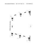
3. The invention claimed is: A Helicopter Autopilot system that utilizes a "Standard Flight Plan Profile" while autopiloting a helicopter to a GPS coordinate that has been input into the onboard computor data base and that identifies a landing location that is shown on the dashboard GPS terrain map display screen, this is depicted in FIG. 1 of the drawings.
Description:
CROSS-REFERENCE TO RELATED APPLICATIONS
[0001]"Not Applicable"
REFERENCE TO SEQUENCE LISTING
[0002]"Not Applicable"
BACKGROUND OF THE INVENTION
[0003]The Helicopter Autopilot system can autopilot helicopter flight controls using GPS (Global Positioning System) coordinates, accellerometer coordinates and VOR (VHF Omnidirectional Range) radio signals. VOR and the Victor airways is primarily used by autopilot systems in today's aircraft.
[0004]The Helicopter Autopilot will comprise of a GPS receiver installed in the front of the helicopter and will be continually receiving GPS coordinate data. One method of operating the autopilot is to fly a flight plan and record these received GPS coordinates on CD-ROM using the onboard computor and GPS terrain map display screen. The autopilot can then be used to fly an identical autopilot flight. This is accomplished by computor controlling cyclic, collective pitch, anti-torque and throttle to match the real-time GPS coordinates with the pre-recorded programmed coordinates. The GPS display screen will show a high-lighted pre-recorded magnetic course and the helicopter image showing the pilot's position will be directed to pass through the programmed GPS coordinates.
SUMMARY OF THE INVENTION
[0005]In summary the operation of the Helicopter Autopilot system can be described in this way: Once the helicopter has been fitted with the combination of GPS receiver, VOR, magnetic compass, accellerometers, microprocessors, servo motors, GPS horizon display screen and GPS terrain map display screen, this onboard computor is designed to record received GPS coordinates on CD-ROM and autopilot the helicopter. While flying the programming flight, GPS coordinates that the helicopter passes through are recorded every four (4) to thirty (30) seconds of flight. This sequence of GPS coordinates, from take-off to landing, represents the altitude, latitude, longitude and velocity of the helicopter as it is flown through this flight plan. To fly this flight plan again, using the autopilot, the CD-ROM is engaged and the pre-recorded GPS coordinates appear on the dashboard GPS display screen as a high-lighted magnetic course.
[0006]The Helicopter Autopilot will compare received real-time GPS coordinates, which show the pilot's real-time position at any time on this same GPS display screen, with the pre-recorded GPS coordinates. Automatic flight control adjustments of the cyclic, collective pitch, anti-torque and throttle will be made to align and match the real-time GPS coordinates with the pre-recorded GPS coordinates. This will result in an identical autopiloted flight.
[0007]To autopilot a maneuver such as circling or hovering, the GPS coordinates are recorded during this maneuver and system is engaged to continue circling or hovering. Accellerometers measuring triaxial accellerations are used to monitor flight control adjustments.
[0008]A Standard Flight Plan Profile can be used to autopilot helicopter to a heliport identified by a GPS coordinate input into the GPS terrain map data base. The Hemispherical Cruising Rule is observed, and ascent and descent is controlled. A pre-recorded flight is not necessary.
BRIEF DESCRIPTION OF SEVERAL VIEWS OF THE DRAWINGS
[0009]Here in these drawings, the Helicopter Autopilot is depicted. The drawings show a helicopter autopiloted during a flight to a destination identified by, a GPS coordinate. A Standard Flight Plan Profile is used and a prior programming flight is not required.
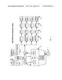
[0010]A block diagram schematic of the helicopter autopilot system with incoming navigational data passing through microprocessors that show the real-time position on the GPS display screen and flight control adjustments will be determined at the GPS display screen to match the real-time coordinates with the pre-recorded coordinates.
[0011]A helicopter hovering is shown where the autopilot can be used to hold this position once the GPS coordinates are recorded on CD-ROM and autopilot is engaged.
[0012]FIG. 1 is a Standard Flight Plan Profile. The drawing shows: (1) helicopter take-off, (2) ascent, (3) to level flight, (4) Approximately one-thousand feet (1000 FT.) from destination, (5) helicopter descent, (6) landing at GPS coordinates.
[0013]FIG. 2 is a Helicopter Autopilot system block diagram schematic. The drawing shows: (1) GPS receiver, (2) magnetic compass, (3) VOR, (4) accellerometers, (5) PCI atomic clock, (6) microprocessors or CPU's, (7) GPS Horizon display screen, (8) CD-ROM, (9) GPS terrain display screen, (10) Cockpit flight controls, (11) microprocessors controlling range of adjustment, (12) servo, (13) mechanical systems.
[0014]FIG. 3 is a helicopter hovering using autopilot flight control. The drawing shows: (1) the received GPS radio signals from the orbiting satellites, (2) autopiloted helicopter, (3) GPS receiver installed in helicopter, (4) Lifting line, (5) cable hook.
DETAILED DESCRIPTION OF THE INVENTION
[0015]The Helicopter Autopilot can be described as a navigational aid for helicopters, that can also automatically make flight control adjustments for yaw, pitch, roll and airspeed changes, while aligning the helicopter to a pre-recorded GPS coordinate course and altitude sequence. The pre-recorded GPS coordinates are stored on CD-ROM during a programming flight and then are made available to the onboard computor when this flight plan is autopiloted. The helicopter's real-time GPS coordinates will show a helicopter image on the GPS display screen. This is the pilot's position with reference to terrain and latitude and longitude. The pre-recorded GPS coordinates will be high-lighted on this same display screen and represents the magnetic course flown. Using this display screen for alignment, main rotor tilt (cyclic) and tail rotor (anti-torque) adjustments will be automatically made by onboard computor as the helicopter's real-time GPS coordinates are matched with the pre-recorded GPS coordinates. The main rotor collective pitch control and throttle will be computor controlled and adjustments made to match the altitude and velocity of these same pre-recorded GPS coordinates. An identical helicopter flight plan is the result obtained with this autopilot system. Several flight plans to various destinations can be flown and stored on CD-ROM in this way and engaged to autopilot the helicopter.
[0016]Three (3) methods of operation can be used with this autopilot.
[0017]1.) Fly and record an entire flight, and then fly an identical autopiloted flight.
[0018]2.) Fly and record a maneuver such as circling or hovering and engage autopilot to continue flying maneuver at any time during a flight.
[0019]3.) Input GPS coordinates of destination into GPS data base and fly to destination using a Standard Flight Plan Pro-file.
User Contributions:
comments("1"); ?> comment_form("1"); ?>Inventors list |
Agents list |
Assignees list |
List by place |
Classification tree browser |
Top 100 Inventors |
Top 100 Agents |
Top 100 Assignees |
Usenet FAQ Index |
Documents |
Other FAQs |
User Contributions:
Comment about this patent or add new information about this topic:
| People who visited this patent also read: | |
| Patent application number | Title |
|---|---|
| 20160076553 | CENTRIFUGAL COMPRESSOR AND TURBOCHARGER |
| 20160076552 | COMPOSITE AIRFOIL STRUCTURES |
| 20160076551 | IMPELLER AND FLUID MACHINE |
| 20160076550 | Redundant ESP Seal Section Chambers |
| 20160076549 | PUMP CONTROL FOR OPERATION ON A VARIABLE PRESSURE FORCE MAIN |
Images included with this patent application:
 |  |
 |  |
| Similar patent applications: | |
| Date | Title |
|---|---|
| 2011-11-24 | Vehicle calibration using data collected during normal operating conditions |
| 2010-02-04 | Device for rest managment for aircraft pilot |
| 2011-12-08 | Vehicle-mounted information processing apparatus and information processing method |
| 2009-03-05 | Bicycle computer having position-determining functionality |
| 2009-03-12 | Onboard trip computer for emissions subject to reduction credits |
| New patent applications in this class: | |
| Date | Title |
|---|---|
| 2016-06-02 | Aircraft, systems, and methods for trim control in fly-by-wire aircraft systems |
| 2016-05-05 | Dynamic collision-avoidance system and method |
| 2016-03-10 | Context-based flight mode selection |
| 2015-12-24 | Aircraft landing monitor |
| 2015-11-26 | Upgraded flight management system and method of providing the same |
| New patent applications from these inventors: | |
| Date | Title |
|---|---|
| 2012-05-31 | Accelerometer autopilot system |
| 2008-12-04 | Gps autopilot system |
| Top Inventors for class "Data processing: vehicles, navigation, and relative location" | |
| Rank | Inventor's name |
|---|---|
| 1 | Anthony H. Heap |
| 2 | Ajith Kuttannair Kumar |
| 3 | Christopher P. Ricci |
| 4 | Roderick A. Hyde |
| 5 | Lowell L. Wood, Jr. |